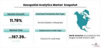
In recent years, the agriculture industry has been experiencing a profound transformation with the integration of geospatial analytics. Geospatial analytics refers to the collection, analysis, and interpretation of data related to geographic locations. By harnessing the power of satellite imagery, GPS technology, and advanced data analytics, farmers and agricultural stakeholders are revolutionizing the way they approach crop management, resource allocation, and overall decision-making. This article explores the ways in which geospatial analytics is driving a significant revolution in the agriculture sector. The geospatial analytics market is projected to grow from USD 76 billion in 2021 to USD 167.39 billion by 2028 at a CAGR of 11.78% during the forecast period.
One of the most prominent applications of geospatial analytics in agriculture is precision farming. With the help of high-resolution satellite imagery and drones, farmers can now monitor their fields with unprecedented accuracy. Geospatial analytics enables the identification of variability in soil health, moisture levels, and crop health across different sections of a field. This knowledge allows farmers to create site-specific management strategies, applying the right amount of water, fertilizers, and pesticides precisely where and when they are needed. Precision farming not only optimizes crop yield but also minimizes the unnecessary use of resources, reducing environmental impacts.
Geospatial analytics empowers farmers to continuously monitor their crops throughout the growing season. By utilizing remote sensing technologies, farmers can identify potential issues early on, such as nutrient deficiencies, water stress, or disease outbreaks. This early detection enables quick and targeted responses, preventing the spread of diseases and reducing crop losses. Additionally, the analysis of historical geospatial data can help identify patterns and trends, allowing farmers to anticipate and plan for future challenges.
Water scarcity is a significant concern for agriculture, especially in arid regions. Geospatial analytics plays a crucial role in optimizing water resource management. Through satellite-based evapotranspiration monitoring, farmers can accurately assess the water needs of their crops. By understanding crop water requirements and actual water availability, they can make informed decisions about irrigation scheduling, ensuring water is used efficiently. This not only conserves water but also reduces energy costs associated with pumping.
Geospatial analytics has transformed the crop insurance sector. Traditional insurance relied on manual assessments and historical data, which could be time-consuming and imprecise. With geospatial analytics, insurers can assess crop health and yield potential in real-time, accurately quantifying the risks involved. Farmers also benefit from this approach, as they can access fairer insurance premiums based on actual field conditions and historical performance. This encourages better risk management and incentivizes sustainable farming practices.
Geospatial analytics is not limited to the on-field applications but extends its impact throughout the agricultural supply chain. By integrating geospatial data with logistics and distribution systems, agricultural products can be efficiently transported from farm to market. Real-time tracking and monitoring of shipments enable better inventory management and reduce wastage. This optimization in the supply chain not only benefits the farmers and agribusinesses but also leads to reduced food losses and improved food security on a global scale.
The ability to analyze vast amounts of geospatial data aids in understanding land use patterns and trends. This knowledge helps in identifying areas with high conservation value or ecological significance. Conservationists and policymakers can use geospatial analytics to plan and implement measures to protect biodiversity, maintain vital ecosystems, and preserve natural resources. It also allows for monitoring deforestation and illegal land use, promoting sustainable practices and environmental stewardship.
In conclusion, geospatial analytics has emerged as a game-changer in the agriculture industry. Through precision farming, crop monitoring, efficient resource management, risk assessment, and conservation efforts, it has transformed the way farmers produce and manage crops. As technology continues to advance, geospatial analytics will become even more sophisticated, leading to further improvements in agricultural productivity, sustainability, and resilience in the face of climate change. The revolution sparked by geospatial analytics is not only benefiting farmers but also contributing to global food security and a more sustainable future.